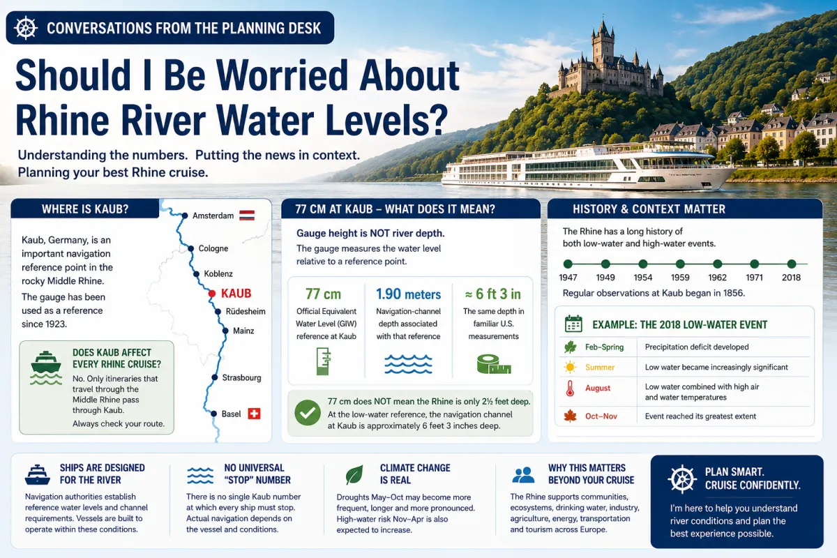
Should I Be Worried About Rhine River Water Levels?
Conversations from the Planning Desk
“Should I Be Worried About Rhine River Water Levels?”
One question that recently came up while planning a Rhine river cruise was:
“I've heard about low water on the Rhine. How do I know whether my cruise could be affected?”
It's a good question, especially when headlines start quoting Rhine water levels in centimeters.
You might see a report that says “Kaub is at 77 cm” and naturally think: Is the river really only 2½ feet deep? How can a ship possibly sail through that?
Fortunately, that's not what the number means.
Here's how I explain Rhine water levels from the planning desk.
📍 First: Why Does Everyone Talk About Kaub?
Kaub, Germany sits along the rocky Middle Rhine.
Germany's Federal Institute of Hydrology (BfG) says the Kaub gauge has been used as a reference gauge for Rhine discharge since 1923. It is especially important for evaluating navigation-channel depths because of its central location in the rocky Middle Rhine section.
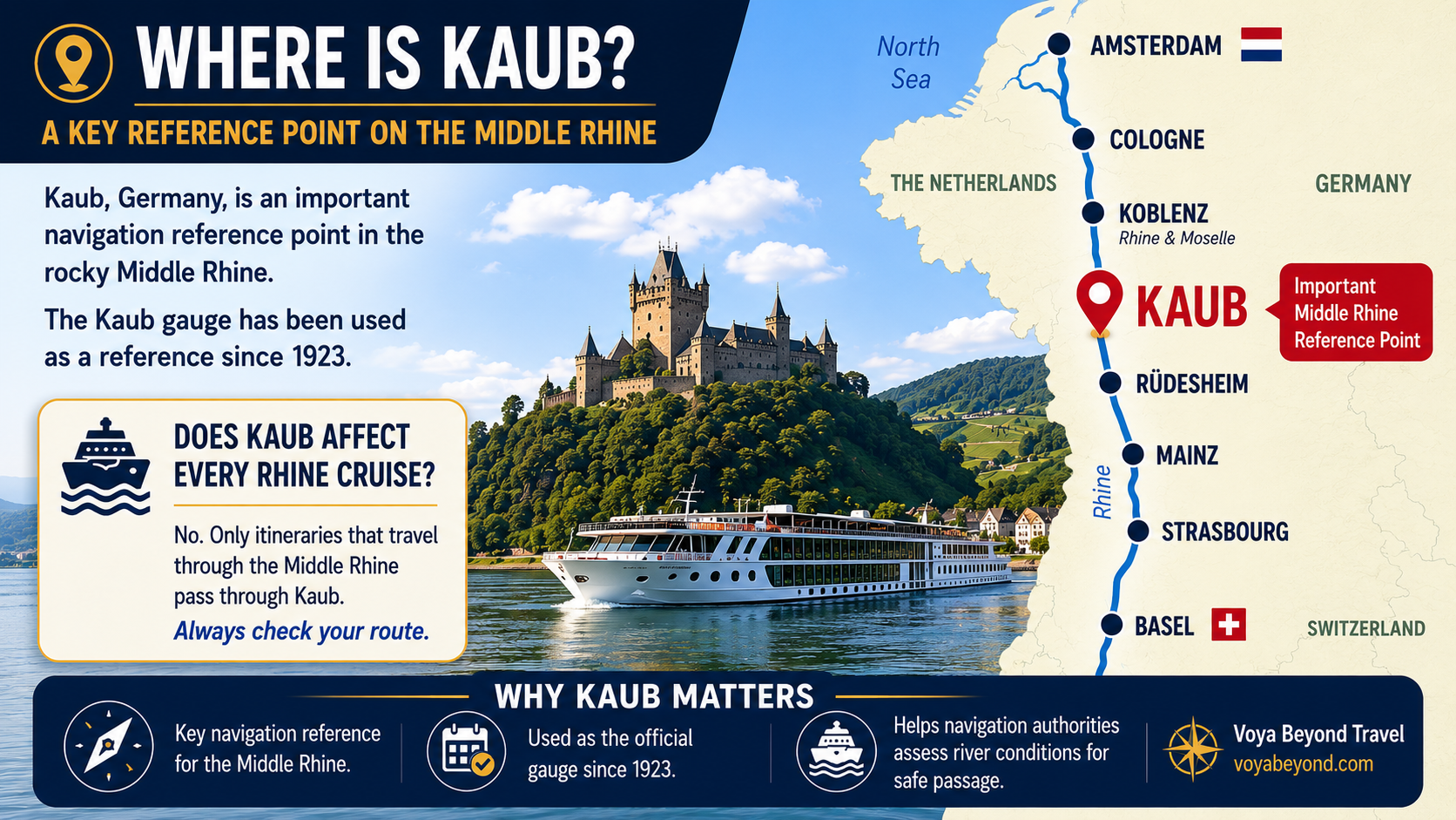
Does Kaub matter to every Rhine cruise?
No.
That's an important distinction.
A cruise advertised as a “Rhine itinerary” doesn't necessarily travel the entire Rhine. Kaub matters when the ship's actual route takes it through that section of the Middle Rhine.
So before worrying about the Kaub reading, ask:
Does my particular itinerary actually travel through Kaub?
📏 What Does “77 cm at Kaub” Actually Mean?
This is probably the biggest misunderstanding when Rhine water levels are reported.
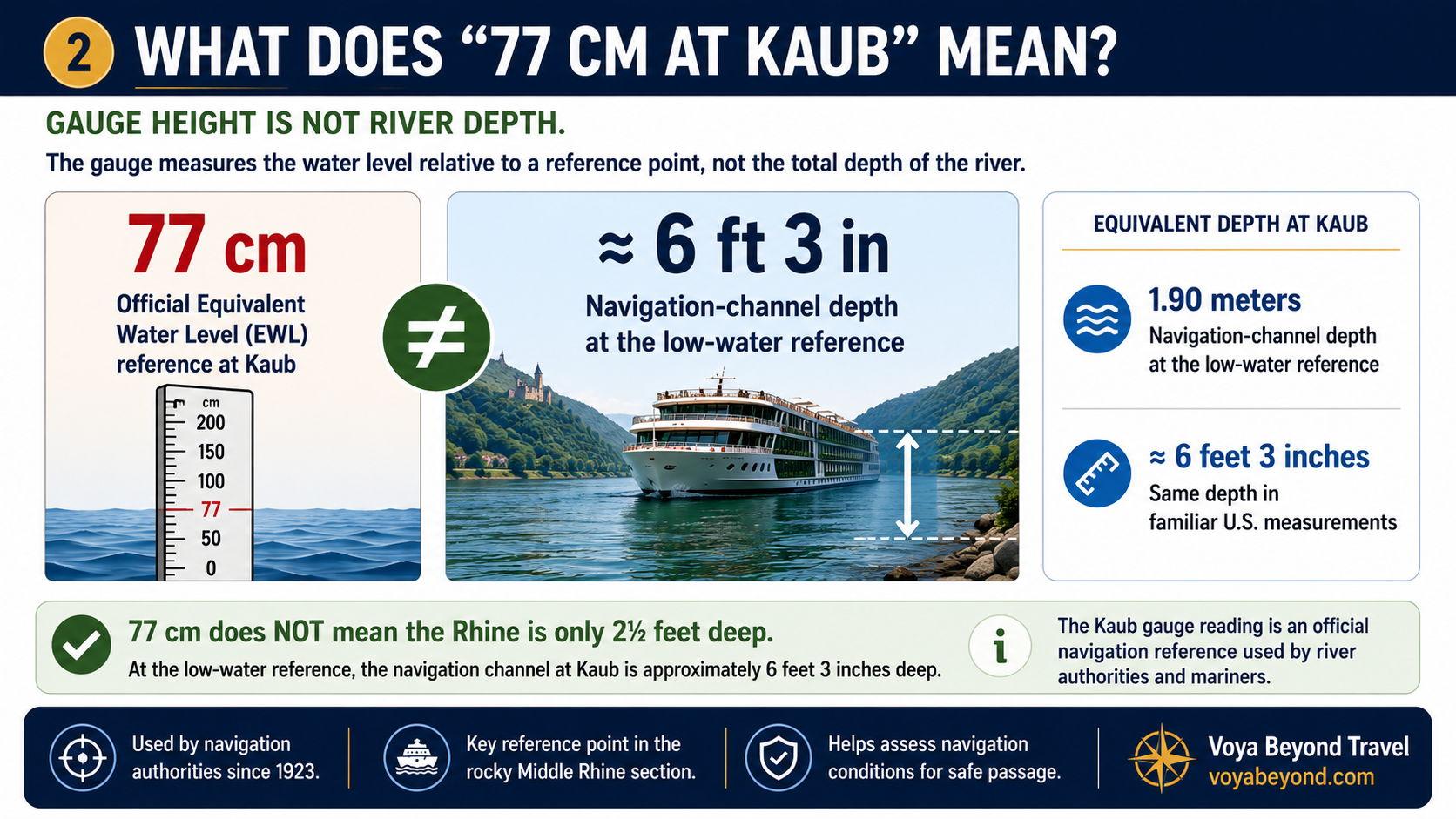
When you hear that Kaub is at 77 cm, it's easy to assume that means the Rhine itself is only about 2½ feet deep.
It doesn't.
The Kaub gauge measures the water level relative to an established reference point—it is not a measurement of the river's total depth.
The Central Commission for the Navigation of the Rhine (CCNR) lists 77 cm as Kaub's official Equivalent Water Level (GlW/EWL). The current reference took effect January 1, 2023 and applies through 2031.
So what does that mean for navigation?
This is where the distinction between gauge height and navigation-channel depth becomes important.
At Kaub's low-water reference, the corresponding navigation-channel depth is approximately 1.90 meters, or about 6 feet 3 inches.
The graphic below shows the difference.
The important takeaway
A headline reporting “77 cm at Kaub” does not mean a river cruise ship is trying to navigate through 2½ feet of water.
It tells us where the river stands relative to an official navigation reference.
That distinction is important because it gives travelers much better context when they see Rhine water-level numbers reported in the news.
And it leads to the next question:
If 77 cm is a low-water reference, does that mean ships have to stop when the Rhine falls below it?
Not necessarily.
That's where the vessel, available navigation depth and real-time conditions start to matter.
🟢🟡🔴 So What Do the Numbers Tell Us?
For travelers, the most important thing to understand is that Kaub is a reference point—not a universal stoplight for river traffic.
The official Equivalent Water Level (GlW) at Kaub is 77 cm. When the gauge falls below that reference, available navigation depth decreases and the conditions affecting an individual vessel become increasingly important.
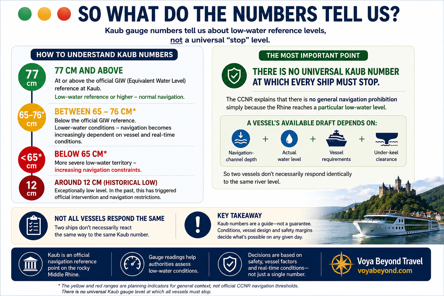
The 65–76 cm and below-65 cm ranges shown in the graphic are planning indicators, not official CCNR navigation thresholds. They are included to help put progressively lower readings into context.
There is no universal Kaub number at which every ship must stop.
The CCNR explains that reaching a particular low-water level does not automatically create a general prohibition on navigation.
Whether a vessel can continue depends on factors such as:
Navigation-channel depth + actual water level + vessel requirements + under-keel clearance
That's why two vessels can face the same Kaub reading and make different operational decisions.
Ultimately, navigation decisions are made using the actual conditions, characteristics of the vessel and appropriate safety margins—not simply one number on the Kaub gauge.
🗺️ Why Kaub Can Be More Important Than Other Parts of the Rhine
The Rhine isn't equally deep everywhere.
The Middle Rhine contains a rocky section where navigation depth can become particularly important during low water. BfG specifically identifies Kaub's location in this rocky section as a reason the gauge is so significant for Rhine navigation.
That also explains why a headline about Kaub shouldn't automatically be applied to every Rhine itinerary.
Your route matters.
A sailing that needs to pass through the Middle Rhine faces different considerations from one operating somewhere else on the river system.
🧭 What Should a River Cruise Traveler Remember?
After all the numbers, gauges and historical context, the key points are actually pretty simple.
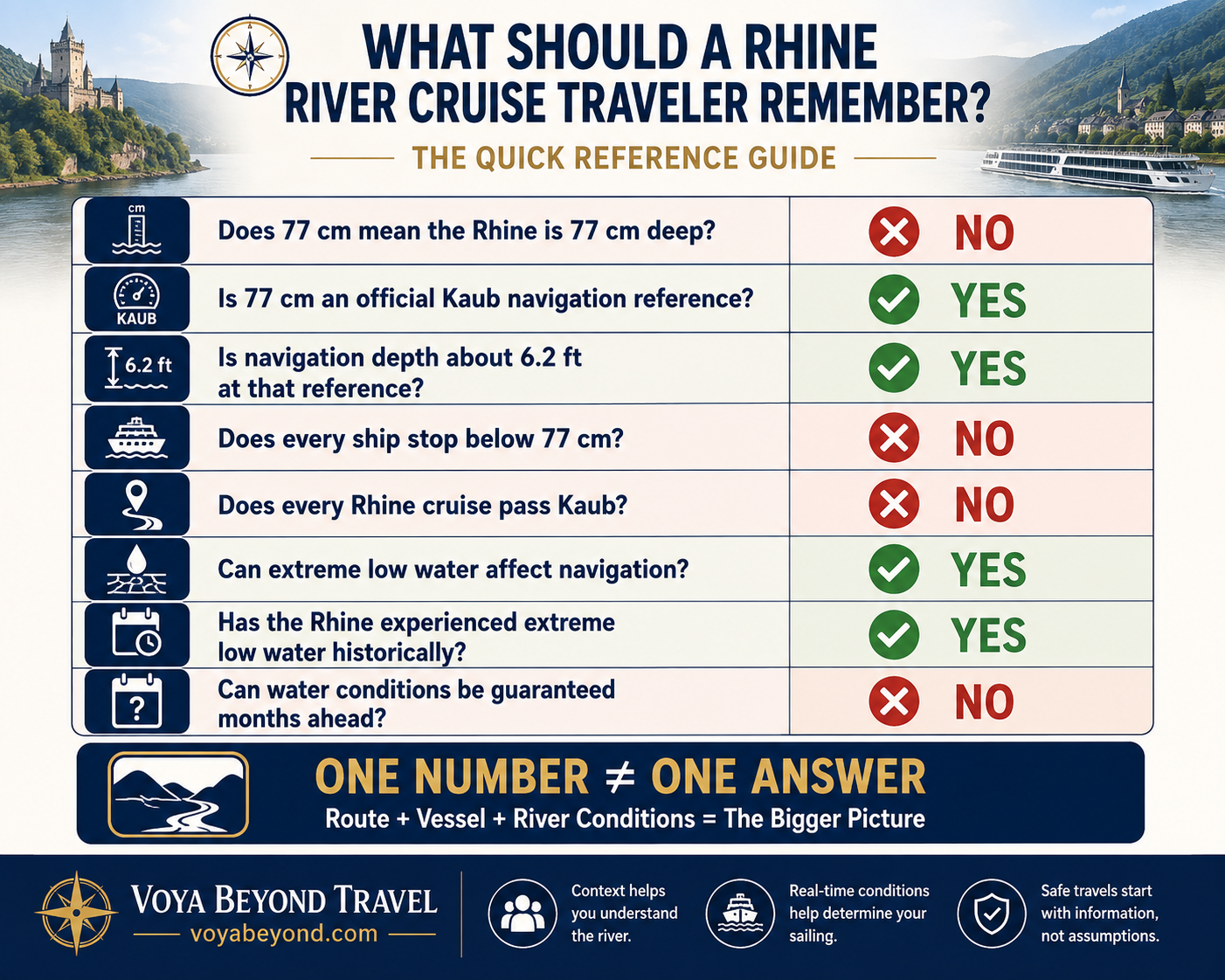
The biggest takeaway is this:
A Kaub reading provides important information about river conditions, but one number alone cannot tell you whether your particular river cruise will operate normally.
Your itinerary matters. The vessel matters. The section of the Rhine being traveled matters. And most importantly, actual conditions closer to the sailing date matter.
That's why I prefer to give travelers context rather than guarantees.
Water levels also have a historical and seasonal context—the Rhine has experienced major low-water events before, and conditions can vary considerably throughout the year.
Before You Worry About a Rhine Water-Level Headline…
Ask three questions:
1. Does my itinerary actually travel through Kaub?
2. What does the gauge reading mean for navigation—not simply the number in centimeters?
3. What are the actual conditions as my sailing date approaches?
Those questions tell us considerably more about your cruise than a single number in a headline.
Want to Go Deeper?
This is the first article in my Rhine Water Levels series.
In Part 2, we'll look more closely at the ships themselves: how river vessels are designed for these waterways, what happens as available navigation depth decreases and why there isn't one magic number that tells every Rhine ship when to stop.
Then in Part 3, we'll look at the Rhine's history—including the extreme 2018 low-water event—seasonal patterns and what climate projections could mean for future river cruising.
From the Planning Desk
River cruising involves more than choosing a ship and finding the lowest fare.
Route, season, river conditions and the characteristics of the vessel can all matter.
My job isn't to promise that Mother Nature will cooperate.
It's to help you understand the information that's available, put it into context and make a more informed decision about your vacation.
If you're considering a Rhine river cruise and water levels are a concern, I can help you look at your actual itinerary and determine how the sections of the river you're traveling relate to current conditions.
Brandon Sams
Travel Consultant
European River Cruise Specialist (ERCS)
650-541-9409