
Classic Danube Water Levels: Wachau, Vienna, Bratislava and Budapest
This is the Danube most American river-cruise travelers recognize.
Wachau. Vienna. Bratislava. Budapest.
It is also the section where a single headline about “low Danube water” can be especially misleading.
Within this relatively compact cruise corridor, the river passes through controlled sections, free-flowing shallows, a major dam system and the long Hungarian reach toward Budapest.

The Classic Danube links some of Europe’s most recognizable river-cruise destinations, but navigation conditions can change from one section to the next. Understanding where the key gauges, shallow reaches and regulated sections sit along the route gives travelers a much clearer picture than a single “Danube level” ever could.
DANUBE WATER LEVELS SERIES · ARTICLE 5 OF 7
New to the Danube Water Levels Series?
If you’re joining the conversation here, the first four articles build the foundation for understanding why river conditions can vary so much along a Danube cruise:
1. Understanding Danube Water Levels: The Gauges That Tell the Story
Learn what river gauges actually measure, why gauge height is not the same as navigable depth, and why a single water-level number cannot describe the entire Danube.
2. Is Low Water on the Danube Something New? A Look at the River’s History
Put today’s low-water headlines into perspective by looking at historic droughts, changing river conditions and the Danube’s long navigation history.
3. Why Isn’t the Entire Danube Controlled? Dams, the Green Movement and a Changing River
Explore why some stretches of the Danube are controlled by dams and locks while others remain free-flowing—and why that difference matters for river cruising.
4. Upper Danube Water Levels: Germany to the Wachau
Follow the river from Germany through Passau, Linz and the Wachau to see how tributaries, regulated sections, Pfelling, Kienstock and local fairway depths shape the navigation picture.
Now we continue downstream through one of the Danube’s most popular river-cruise corridors—the Wachau, Vienna, Bratislava and Budapest.
Wachau: start with Kienstock
Coming downstream through Austria, the Kienstock gauge is one of the useful reference points for the Wachau.
But remember the rule from our first article:
Gauge level is not the same thing as channel depth.
Danube FIS publishes actual soundings at shallow Wachau locations such as Weißenkirchen and Hofarnsdorf. Those soundings provide the operational context that the gauge alone cannot.
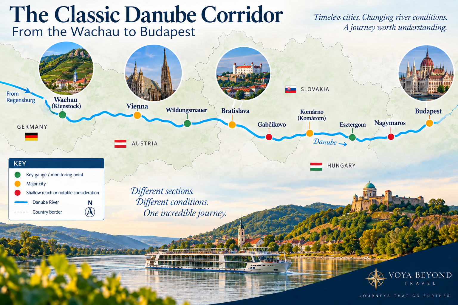
The Classic Danube crosses several different river environments between the Wachau and Budapest. Key reference points such as Kienstock, Wildungsmauer, Bratislava, Gabčíkovo, Nagymaros and Budapest help show how conditions can vary along the route.
Vienna is not the whole story
Travelers often search for the “Vienna water level.”
For cruise navigation, the more important question may be what is happening east of Vienna.
This is where the Danube includes free-flowing shallow reaches that can become sensitive during drought.
Wildungsmauer: a gauge worth remembering
Wildungsmauer, east of Vienna, is one of the most useful reference gauges in this corridor.
Danube FIS uses it as the reference station for multiple Austrian bottlenecks, including shallow reaches around Lobau, Buchenau and Fischamündung.
In other words, if I am evaluating a Vienna-to-Bratislava cruise segment during a low-water event, I want more than a Vienna city reading.
I want Wildungsmauer plus the current fairway soundings.
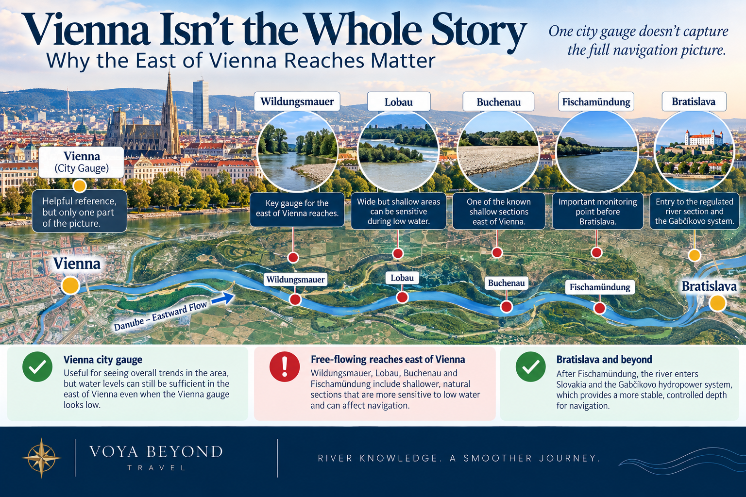
Vienna’s city gauge is only part of the navigation picture. East of Vienna, free-flowing reaches such as Wildungsmauer, Lobau, Buchenau and Fischamündung can respond differently to low water before the river reaches Bratislava and the more regulated Gabčíkovo system.
Bratislava and Gabčíkovo
Bratislava sits near another major change in the river.
Downstream is the Gabčíkovo hydropower system, operating since 1992.
Gabčíkovo diverts much of the river’s flow through a power channel, regulates water for navigation and provides flood protection. It also profoundly altered the surrounding river and wetlands—one reason the original Gabčíkovo–Nagymaros project became such an important environmental controversy.
For navigation, this regulated section behaves differently from a free-flowing reach.
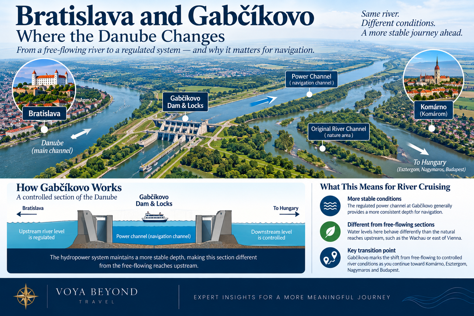
Near Bratislava, the Danube shifts from more free-flowing reaches into the regulated Gabčíkovo system. That change can create more stable navigation conditions and is one reason river behavior here differs from the Wachau and the shallow reaches east of Vienna.
From Slovakia into Hungary
Downstream, useful monitoring points include:
Bratislava / Devín
Medveďov
Nagybajcs / Gönyű
Komárno / Komárom
Esztergom
Nagymaros
Budapest
These gauges allow us to see whether a low-water trend is localized or continuing through the corridor.
Nagymaros and the Danube Bend
Near Nagymaros, the Danube turns through one of its most scenic sections before continuing toward Budapest.
Nagymaros also carries historical significance.
It was intended to be part of the original Gabčíkovo–Nagymaros dam system. Hungary suspended and ultimately abandoned its part of the project amid environmental and political opposition.
Today, the absence of that planned barrage is part of the reason this section’s story differs from the heavily regulated reaches elsewhere.
Budapest: dramatic, important—and easy to misunderstand
Budapest receives enormous attention during low-water events because the river runs through the center of one of Europe’s great capitals.
When levels fall, exposed banks and bridge foundations create striking photographs.
The Budapest gauge is absolutely worth watching.
But a Budapest reading of 50 centimeters does not mean the Danube is only 50 centimeters deep.
It is a gauge height relative to a local datum.
Navigation decisions depend on the actual channel, vessel draft, safety margin, upstream/downstream conditions and navigation notices.
Why this corridor matters so much to river cruising
This geography appears in countless versions of Danube itineraries offered by AmaWaterways, Viking, Avalon, Uniworld, Scenic, Emerald, Tauck and others.
Some sail Budapest to Vilshofen. Some reverse direction. Some add Prague before or after. Christmas-market versions use much of the same river.
So when low water develops here, the impact can be visible across the entire river-cruise industry.
What happens if one section becomes impassable?
Cruise lines have several tools:
Change docking locations
Adjust excursion timing
Transport guests by motorcoach around a restricted reach
Reposition ships
In some cases, transfer guests between sister ships operating on opposite sides of a problem area
That last option is why a cruise can sometimes continue even when one vessel cannot sail the complete original route.
It is also why travelers should distinguish between a modified river cruise and a trip that has effectively become a motorcoach tour.
The degree of disruption matters.
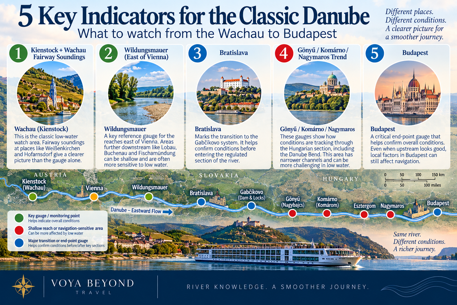
The clearest picture of Classic Danube navigation comes from watching several locations together. Kienstock and Wachau fairway soundings, Wildungsmauer, Bratislava, the Hungarian Danube Bend trend and Budapest each reveal a different part of current river conditions.
The five indicators I would prioritize
For the classic Wachau-to-Budapest corridor, I would pay especially close attention to:
Kienstock and Wachau fairway soundings
Wildungsmauer and east-of-Vienna bottlenecks
Bratislava
The Gönyű / Komárno / Nagymaros trend
Budapest
Then I would add rainfall across the upstream watershed.
This is much more informative than asking for one Danube number.
Next: We continue beyond Budapest into Croatia, Serbia, the Iron Gates, Bulgaria and Romania—where the river becomes wider, the cruise itineraries longer and the navigation story changes again.
In This Series
Danube Water Levels Series · Article 5 of 7
Previous Article: Upper Danube Water Levels: Germany to the Wachau | Series: Danube Water Levels | Next Article: Middle & Lower Danube Water Levels: Budapest to Romania and the Black Sea
Danube Water Levels Explained: Gauges, Depth & River Cruises
Why Isn’t the Entire Danube Controlled? Dams, the Green Movement and a Changing River
Classic Danube Water Levels: Wachau, Vienna, Bratislava and Budapest — Current article
Middle & Lower Danube Water Levels: Budapest to Romania and the Black Sea
What Happens When a Danube River Cruise Ship Can't Get Through?
Planning a Danube River Cruise?
River conditions are only one part of choosing the right itinerary, ship and time of year. If you're considering a Danube cruise, I can help you compare the options and understand how the different routes may fit your travel plans.
Schedule a consultation and let's talk through your trip.
Sources & Further Reading
This article is part of Conversations from the Planning Desk™ and is intended to help travelers understand river conditions—not to predict the operation of a specific sailing. River levels, fairway depths and cruise operations can change quickly.
Danube Commission — Main gauges and navigation information: https://www.danubecommission.org/dc/en/danube-navigation/
Danube FIS Portal — Current navigation bottlenecks and fairway soundings: https://www.danubeportal.com/en/bottleNeck
ICPDR — Danube River Basin, climate adaptation and hydromorphology: https://www.icpdr.org/