
Danube Water Levels Explained: Gauges, Depth & River Cruises
Understanding Danube Water Levels: The Gauges That Tell the Story
DANUBE WATER LEVELS SERIES · ARTICLE 1 OF 7
When a traveler sees a headline saying the Danube is at “50 centimeters” in Budapest, the natural reaction is: How can a river cruise ship possibly sail in 20 inches of water?
It sounds alarming because the number is easy to misunderstand.
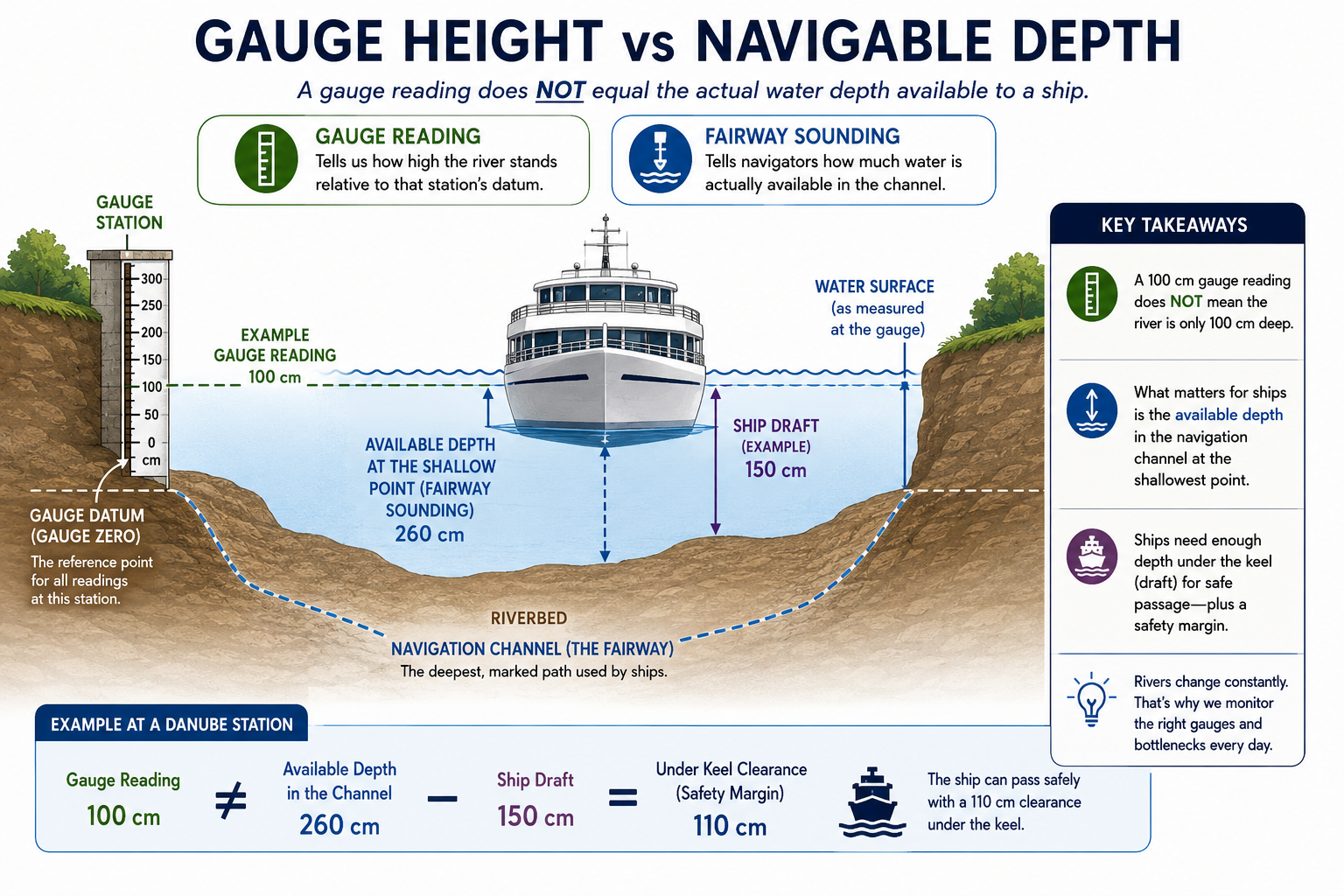
A river gauge does not normally tell you the total depth of water beneath a ship. It measures the height of the river relative to a locally established reference point, or gauge datum. A reading of 50 centimeters at one station therefore cannot be compared directly with 50 centimeters at another station—and it certainly does not mean the river is only 50 centimeters deep.
That distinction is the starting point for understanding Danube river conditions.
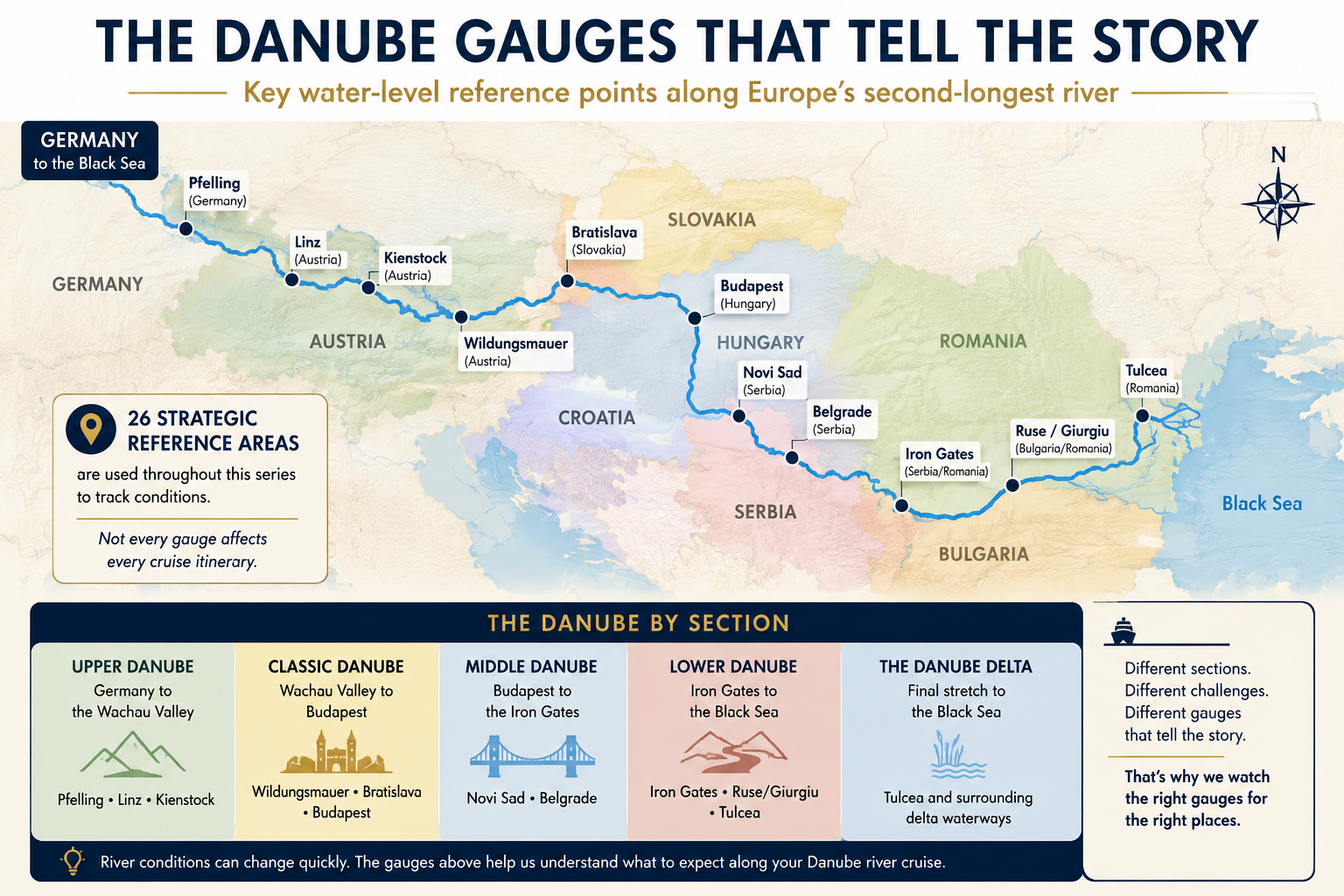
One river, many measurement points
The Danube travels roughly 1,775 miles (2,857 kilometers) from Germany’s Black Forest to the Black Sea. Along the way it passes through or borders ten countries, while its enormous drainage basin reaches nineteen countries.
There is no single Danube equivalent of a universal “water-level number.”
National water authorities maintain numerous gauges, and the Danube Commission publishes a long list of main gauges used to understand conditions along the navigable river. For travelers, the useful question is not, “What is the Danube level today?” It is:
Which gauges and navigation bottlenecks apply to the section my ship is sailing?
26 strategic reference points for understanding the cruise river
For our traveler-focused monitoring, I use a set of strategic reference areas spanning the navigable Danube. These are not the only gauges on the river; they are a practical backbone for understanding the major cruise corridors.
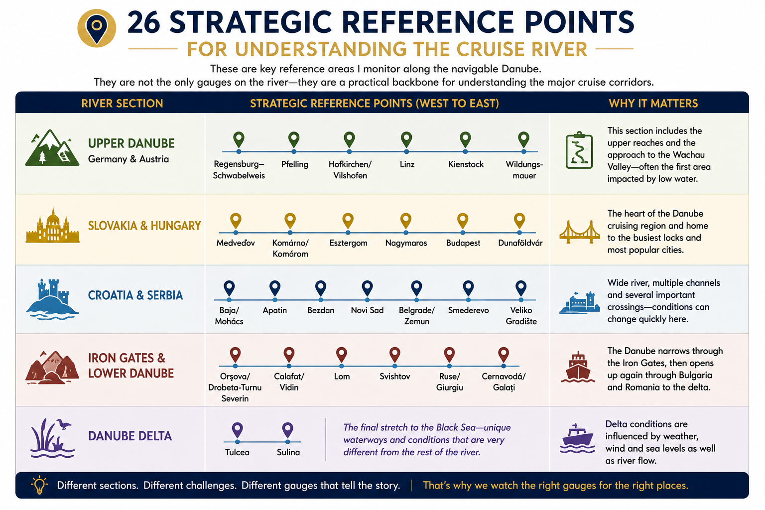
The Danube Commission’s full gauge tables contain many more stations between these points. That extra detail becomes important when a particular reach develops a problem.
Gauge height versus navigable depth
This is the concept that matters most.
A gauge reading tells us how high the river stands relative to that station’s fixed reference point, called the datum or gauge zero. Think of it as the starting point on a measuring scale—it is not the riverbed and does not tell us the actual depth of the river.
A fairway sounding tells navigators how much water is actually available in the navigation channel at a particular shallow location.
The Danube FIS Portal publishes current bottleneck information for critical reaches. In the Wachau, for example, shallow areas near Weißenkirchen, Hofarnsdorf and Schwallenbach are referenced to the Kienstock gauge. East of Vienna, shallow reaches such as Lobau, Buchenau and Fischamündung are referenced to Wildungsmauer.
That is far more useful to a captain than simply hearing that “Vienna is low.”
Why one gauge cannot describe the Danube
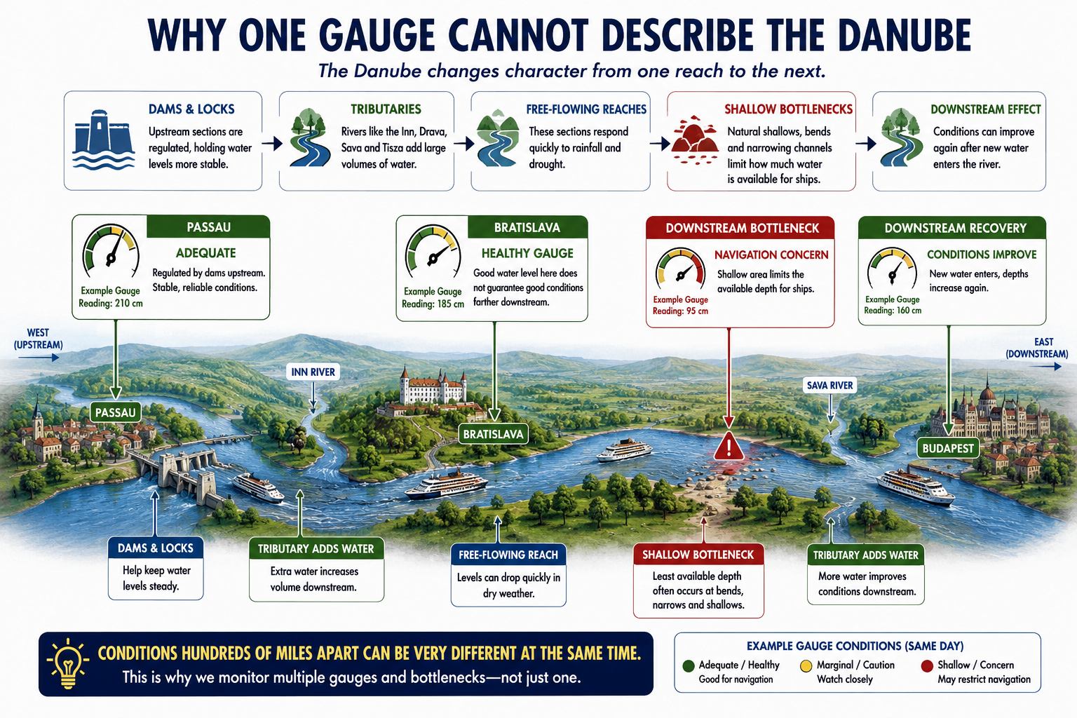
The river changes character repeatedly.
Parts of the Upper Danube are heavily regulated by dams and locks. Other sections are free-flowing and respond more directly to rainfall and drought. Major tributaries such as the Inn, Drava, Sava and Tisza can substantially change the volume of water downstream.
A ship can therefore encounter adequate conditions near Passau while facing a shallow free-flowing reach hundreds of miles later.
This is why a photograph of exposed riverbank in Budapest does not tell us whether a ship can pass through the Wachau—and why a healthy reading in Bratislava does not automatically guarantee trouble-free navigation all the way to Budapest.
The numbers river operators actually care about
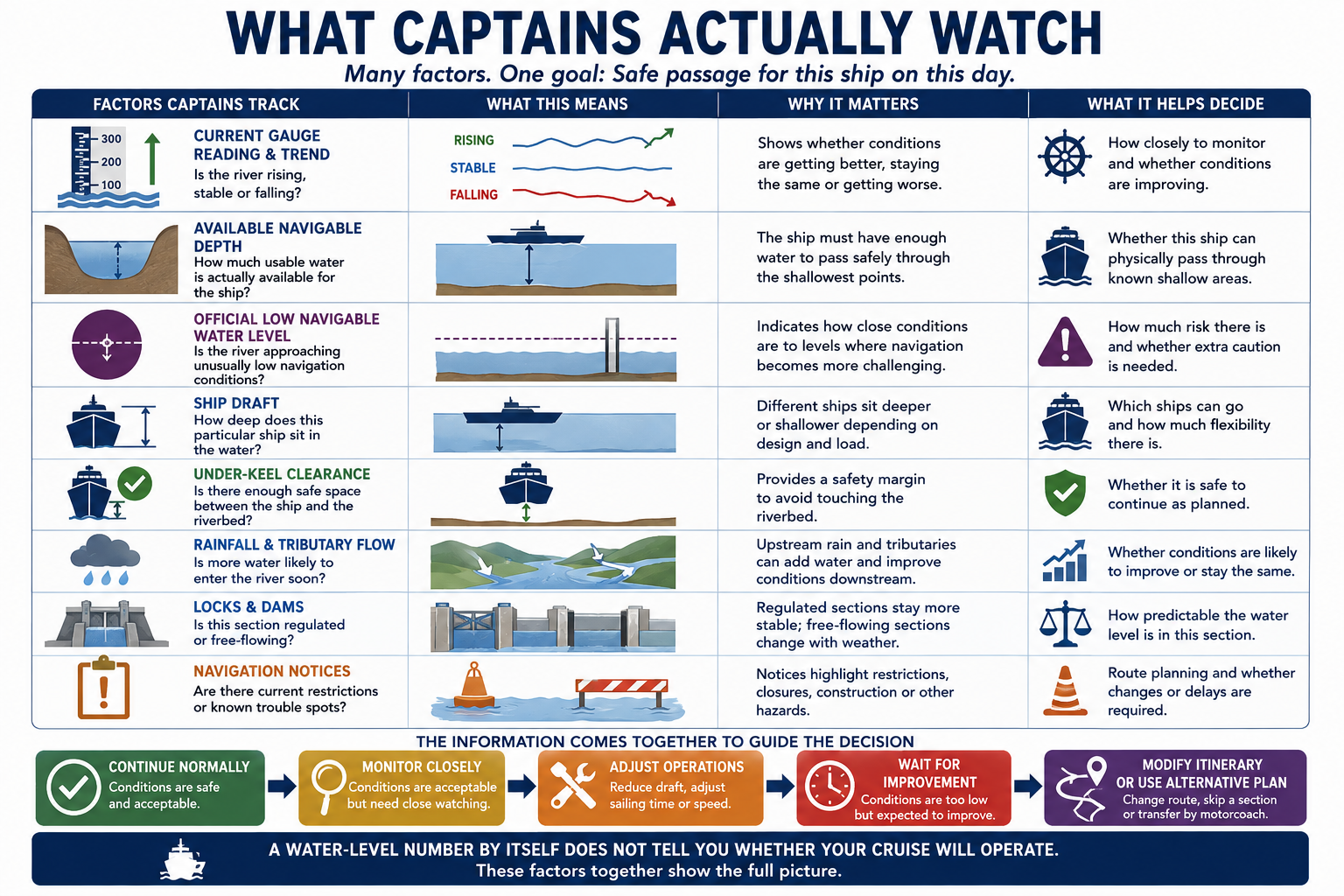
River operators combine several pieces of information:
Current gauge reading and trend — Is the river rising, stable or falling?
Available navigable depth — How much usable water is actually available for the ship?
Official low navigable water level — Is the river approaching unusually low navigation conditions?
Ship draft — How deep does this particular ship sit in the water?
Under-keel clearance — Is there enough safe space between the ship and the riverbed?
Rainfall and tributary flow — Is more water likely to enter the river soon?
Locks and dams — Is this section's water level naturally changing or being regulated?
Navigation notices — Are there current restrictions or known trouble spots?
This is also why two cruise companies—or even two ships from the same company—can make different operational decisions on the same river.
What travelers should watch
Don't obsess over a single number.
Instead, focus on a few simple questions:
Where is the problem? — Is it actually on the portion of the Danube your cruise will sail?
Is the water rising or falling? — The direction of the trend can matter as much as today's reading.
Is navigation actually being affected? — Low water does not automatically mean ships have stopped sailing.
What is your cruise line doing? — Different ships and operators may respond differently to the same conditions.
The most useful question isn't “What is the Danube water level?” It's “Are current conditions affecting my specific itinerary?”
Planning a Danube River Cruise?
River conditions are only one part of choosing the right itinerary, ship and time of year. If you're considering a Danube cruise, I can help you compare the options and understand how the different routes may fit your travel plans.
Schedule a consultation and let's talk through your trip.
Next in the series: Is Low Water on the Danube Something New? We look beyond today’s headlines and put drought and navigation problems into historical perspective.
Sources & Further Reading
This article is part of Conversations from the Planning Desk™ and is intended to help travelers understand river conditions—not to predict the operation of a specific sailing. River levels, fairway depths and cruise operations can change quickly.
Danube Commission — Main gauges and navigation information: https://www.danubecommission.org/dc/en/danube-navigation/
Danube FIS Portal — Current navigation bottlenecks and fairway soundings: https://www.danubeportal.com/en/bottleNeck
ICPDR — Danube River Basin, climate adaptation and hydromorphology: https://www.icpdr.org/